Showing posts with label Blue Marsh Lake. Show all posts

Sunday, October 11, 2009

Blue Marsh Lake (Early Fall Color)


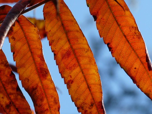
Red Leaves, originally uploaded by Berks_Awhile.

Max and I parked at the parking area where Justa Road ends. Justa Road is just a short distance from the Highland Road and the Old Dry Road Farm where I usually start my walks. The lot has trails going into the surrounding fields or you can follow the gated road towards the lake.

A bunch of riders were unloading their horses from the six or so trailers. We ran into them a couple more times for they covered the same roads as us.

Justa Road meets Sleepy Hollow Road, which runs along a finger of the lake and ends at the ramp. This is my favorite leg of the hike since you can see the lake through the back lit trees. Also, many of the trees were in full color along the lake offering vivid colors to photograph.

A few boats were on the lake, but not the greatest reflections.

I'd estimate that we walked about a 2 miles on a mild and sunny 62 degree day.

--------------

You may have noticed the new larger picture in this blog. I am now using Flickr to store and link to my images. I like the size and the opportunity to share more pictures then this blog can physically handle.

Saturday, May 30, 2009

Blue Marsh Lake (Lake Road Trails - Skinners Loops)


A perfect sunny and 75 weather day at Blue Marsh was equalled by the great and diverse trail system that loops the peninsula.

Heading northwest on SR183, I took the left turn at Old Church Rd which bridges the lake. Less then a mile from SR183, I made a left onto Lake Road. At the end of the no outlet mile drive is a turn around/parking. I believe this is area is called Skinners Loops trail.

Similar to Old Dry Road Farm, an old neglected paved road leads down to the lake. (Maybe a former boat launch or emergency access road). These roads are tree lined and usually obscured from aerial photos.

I knew that I was on a peninsula and that I couldn't get totally lost, but the meandering trails are not clearly named nor trees blazed. I saw a couple obscure trail markers. In retrospect, the basic layout is two adjacent roads that run nearly the length and are occasionally connected by cross paths. All roads and trails connect to the paved artery.

The north road runs along a field and woods and is sun drenched so the sun loving wildflowers were plentiful. As the road transitions into shade and woodlands the flora species changed. The southern road is mainly shaded, but crosses a field too.

Max and I met 4 horse riders and a couple of bikers. The lake was spotted with boats and the shore fishing and swimming.

In summary, it was an enjoyable locale with diverse flora, rolling fields and hills and lake views.

Saturday, January 24, 2009

Old Dry Road Farm (Blue Marsh Lake Is Frozen)


I've been anxious to get back to Old Dry Road Farm at Blue Marsh. A great big blue sky with puffy white clouds made it feel like a Florida sky, but the similarity ends there as the air temp was 34 with gusty cold blasts of wind every few minutes.

One of the best times of year is after they release the fall/winter water. Once the water recedes barren beaches are exposed. River rocks and shale seem to make up the bottom near the shores. Dozens of weathered tree stumps show themselves too.

Due to the prolonged sub-freezing temps the lake was frozen over. I'm very leery of frozen surfaces though for every winter the news has numerous stories about ice related accidents.

After thorough testing, I determined that the ice was indeed thick enough and proceeded to venture out. Max was already running ahead on the icy shoreline. I haven't walked on a frozen lake in many years and it was a surreal experience.

We weren't alone on the ice for there was a lone ice fishermen and numerous frozen over fishing holes from days past. Also, a first for me was seeing three wind powered ice sleds. I believe the sport's called ice sailing.

After about an hour or so hiking on the icy paths and frozen lake, Max was showing signs of being cold, so we headed out.

We passed by the State Hill Boat launch to get close up the ice sail.

Sunday, October 5, 2008

Old Dry Road Fram (Blue Marsh Lake)

Within Blue Marsh Lake is an outdoors men and photographers paradise called the Old Dry Road Farm area. Located off of Brownsville Road via car and by trail from the State Hill Road Boat launch.

All my visits started at the gate on Highland Road where there is a large parking area. You really have to want to get there for the road is dusty or muddy, full of ruts and starts with warning signs stating "road not maintained". No lie.

I love this area because it offers such diversity and you can experience several ecosystems in one visit. Today I walked along corn fields, wild plant fields, in a deciduous and evergreen woods and explored the shores of the lake. Nice views of the surrounding mountains are seen from the higher elevations offering big sky photo ops. I always leave with a diverse collection of images.

From the parking area we headed past the gate down Highland Road to the intersection of Sterners Road. I normally go right and head straight down to the lake. Today Max and I turned left. I suspected we'd end up at the another finger of the lake, but double checked with a couple of walkers who assured me that the lake was just ahead.

Along the lake, some of the trees had changed colors, while many were just starting the process. I just read by George Lepp's Tech Tips in Outdoor Photographer Magazine about taking fall colors. He made great points about bracketing and shooting leaves that are backlit instead of the harsher direct light.

Per the advice of another group of hikers, we followed the trail along the lake until it turns into the unmarked Sleepy Hollow Road. At the "Y" we turned left onto the unmarked Landis Road which lead us back the parking area on Highland Road.

About 60 and 3.2 miles.